In the McDowell County part of the Tug Fork watershed there are four different sites where that the National Oceanic and Atmospheric Administration has gauges.
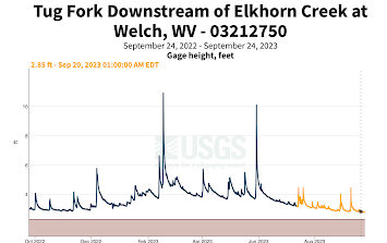
Floods in McDowell County are more common than droughts since it is situated in the mountains. However, currently, all of the gauges are displaying slightly low but relatively normal river levels. USGS also has data at the Welch gauge, which provides a graph from the water level this past year.
The three gauges shown in the map above as green diamonds have the May 02, 2002 flood listed as the all time historical crest since they've been installed. This flood went over the major flood stage in downtown Welch, the county seat of McDowell county. This news article explains that residents in McDowell county thinking that the increases in floods may have been caused by the strip mining in their region. The article also points out that it was the second major flood in 10 months, which can be seen from looking at the gauge in Welch, where the water level was only .33 feet from reaching major flood on July 8, 2021. The same article also writes: "An analysis of state mining records by the Ohio Valley Environmental Coalition shows old and active strip mines covering more than 18,000 acres of McDowell County. Mountaintop removal mines also bury hundreds of miles of streams in the state’s southern counties as companies blast the tops from hills and dispose of the waste rock and dirt in massive valley fills. West Virginia University geology professor Steve Kite says mining is making unprecedented changes to the land." Clearly the flooding in this region is related to the mining in this watershed covered in the previous post. This New York Times article shares that 6 people were killed and 200 homes were destroyed in the flooding and seconds the previous article stating, "residents here and in a half-dozen other coal hollows complain that the 100-year flood timetable of folkloric tradition has been dangerously accelerated by modern timber cutters and strip miners on the surrounding steep mountainsides." Further it shares, "The McDowell County region, one of the poorest in Appalachia, has been in a downward spiral for 50 years, with young people emigrating and welfare replacing coal as an economic force. The county now has only about one-fourth the population of 100,000 it had in busier days, when, long before machine-intensive strip mining, manual labor was at a premium."
In the northwest, there was a big flood in 1977. This 1997 flood reached over the major flood stage near laeger, but, oddly enough it didn't make the flood stage in Panther Creek nearby. All the gauges recorded a historical crest on February 6th 2020, but it only reached a flood level for one of the gauges, Panther Creek. The article speaks with people in Yukon, southwest of Welch where flooding was the worst in West Virginia. West Virginia Public Broadcasting shares that "Without a lot of money coming out of or going into the area, Griffith said it is hard for people to rebuild every time, after every flood."
The increase in flooding with the mining industry and climate change are making it harder and harder to live in McDowell county. The flood risk factor calculates that "there are 16,609 properties in McDowell County that have greater than a 26% chance of being severely affected by flooding over the next 30 years. This represents 56% of all properties in McDowell County."
Data from NOAA:
Welch, WV
Bradshaw, WV:
Panther Creek, WV:
Litwar, near laeger, WV:


Comments
Post a Comment